

Good News Stories from the Field Edition 3

GOES DCS is a High Value Asset and these stories have been collected to show how it benefits its users.
GOES DCS Plays Critical Role During Flooding in British Columbia
A category 5 Atmospheric River made landfall over the Pacific Northwest causing significant flooding and damage to infrastructure in many communities in southwest British Columbia. During the event, landline and cellular networks failed in several BC communities making retrieval of critical real-time data at a number of stream gauges impossible. Thankfully, the majority of stream gauges operated by the National Hydrological Service rely upon the GOES telemetry system and the gauges performed seamlessly through the event.
The data from the GOES stations were critical to guide river forecast and emergency management agencies in flood response efforts.
Brief submission by David Hutchinson from the Vancouver area Received from Paul Campbell, Instrumentation Development Engineer Meteorological Service of Canada Environment and Climate Change Canada Government of Canada
GOES DCS is Critical to the Hydrographic and Oceanographic Service of the Chilean Navy during Tsunami Events
The Chilean National Tsunami Warning Center uses GOES data
collection system to get sea level information using 47 stations
deployed at Easter island, the Chilean Antarctic and the principal
coast.
The system gives them the capacity to check the sea level status
and send warning messages to evacuate the coast, and monitor
until the end of the tsunami alarm. During a previous tsunami event,
the highest tsunami registered was in Chañaral (north of Chile) with
1.74 meter of amplitude. GOES DCS has a history of providing the
only functional telemetry during tsunami events.
DCS is an important system to access our sea level data and monitoring for tsunami events.
Submitted by
Juan Pablo Jorquera García
Hydrographic and Oceanographic Service of the Chilean Navy
(www.snamchile.cl)
GOES DCS Mitigates Terrestrial Communication Gaps and Allows Efficient Fire Hazard Monitoring
The North Carolina Forest Service has 40 Remote Automated Weather Stations (RAWS) and one Organic Soil Moisture station that report weather and soil conditions for use in their fire danger forecasting system. The service’s responsibility includes the Dare Bombing Range in Dare County, NC where a Remote Automatice Weather Station (RAWS) and Organic Soil moisture monitor are deployed. In early March, 2022 the range had a 1,000 acre fire. Forest Service personnel were able to use their remote sensors to identify moisture content compared to soil depth, which was more efficient than taking manual samples and oven drying them.
The Dare Bombing Range and many other locations in North Carolina have no cellular service and the only way to get data near real-time is via satellite.
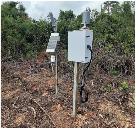
The above picture is the NC Forest Service Organic Soil Station. The large cone is the satellite antenna. The flagging toward the bottom left marks the location of one set of 4 soil probes at 10, 25, 50 and 100 cm deep. On the pole with the satellite antenna is an air temperature and RH sensor and the solar panel. In the box is the datalogger/transmitter and battery. The bucket on that pole is a rain gauge.
Submitted by Meyer “Cabe” Speary Fire Environment Forester North Carolina Forest Service
Chehalis River Basin Flood Authority Warning System Uses GOES DCS in Worst Flooding in a Decade
The GOES DCS forms the backbone of the Chehalis River Basin Flood Authority Flood Warning System. During January of 2022, this system became a critical capability for at-risk residents in Washington State. It was a significant milestone for a system and area that had experienced severe flooding in the past.
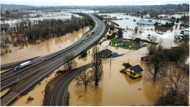
In 2007 and 2009 the Chehalis River Basin experienced catastrophic flooding that, according to Scott Boettcher, staff to the Chehalis River Basin Flood Authority, was not forecasted by the National Weather Service (Warn, 2022). Subsequently, the Office of the Chehalis Basin set out to establish a system of improved water level and flow gages in thirteen locations. This improved system allowed early warning for the 2022 flooding by providing alarms and access to real-time data. “Nearly 35,000 individuals and households logged in and utilized the Chehalis River Basin Flood Warning System during the event to receive emergency updates, and the flood inundation maps available on that site received almost 75,000 hits.” ((Office of the Chehalis Basin, n.d.) The system now contributes as additional data to the National Weather Service for weather prediction.
David C. Curtis had led the system design, development, implementation, operations, and maintenance of this system since 2010.
Submitted by David C. Curtis, Sr. Vice President WEST Consultants, Inc. http://www.WESTconsultants.com
TSUNAMIS MEASUREMENT USING “GOES” SATELLITE SYSTEM BY THE MEXICAN INSTITUTE OF TRANSPORT (2022) Toledano Noe, López Alfredo, Segura David and Ávila Dora
The Mexican Institute of Transport (IMT), operates the National Network of Oceanographic and Meteorological Stations (RENEOM), conformed by autonomous electric equipment, measures the ocean waves characteristics, atmospheric conditions, and sea level variations over the principal ports of Mexico. Due to the development of the RENEOM project, IMT is member of the National Tsunami Warning System (Fig. 1) (SINAT) and collaborates with institutions such as the Secretary of the Navy, the Secretary of Infrastructure, Communications and Transport (SICT), the National Autonomous University of Mexico (UNAM) and the Center for Scientific Research and Higher Studies of Ensenada (CICESE). SINAT's objective is to monitor and warn of possible damage in Mexico caused by a tsunami.
Fig. 1.- National Tsunami Warning System
The Autonomous Stations that measure the sea level, have redundant transmission systems (VHF radio and satellite radio), this provides information to the SINAT continuously and in real time. The data is redundantly sent by two ways, the first, via VHF radio to the Port Authority; and the second, via GOES satellite system, to the IMT facilities and to the National Tsunami Alert Center (operational part of SINAT, directed by the Secretary of Navy).
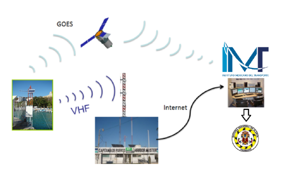
Fig. 2.- Transmission Scheme
Below are two cases of tsunami measurements caused by two different phenomena, the case 1, with a local origin caused by an earthquake on September 7, 2021, near to the Port of Acapulco, Guerrero, Mexico; and the case 2, with a remote origin, on January 15, 2022, caused by the eruption of the Tonga-Hunga Ha´apai volcano, near to the island of Fonuafo'ou, Tonga.
Case 1: September 7, 2021. Port of Acapulco, Guerrero, Mexico
The Mexican Republic is in a high seismicity area due to the interaction of five tectonic plates. The subduction zone of the Cocos Plate, adjacent to the western coast of Mexico, is one of the most active seismic zones in the Western Hemisphere. In addition, the state of Guerrero is located on the boundary limits of the Cocos and North American tectonic plates. Consequently, this region is one of the most seismically active states in the country. The problem in this area is that an earthquake hasn’t occurred in many years; therefore, a higher probability that a high intensity earthquake may occur, produced by the accumulated energy in those plates. This situation occurs between Acapulco and Petatlán, coast of Guerrero. This region is known by seismologists as the Guerrero Gap (Fig. 3).
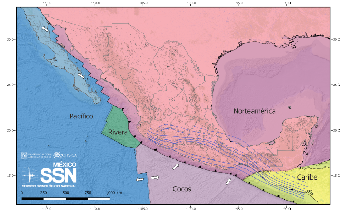
Fig. 3. Tectonic Plates of the Mexican Republic (SSN, 2021)
Earthquake of September 7, 2021
According to the information reported by the National Seismological Service (SSN), on September 7, 2021, at 20:47 Mexico-CST, an earthquake with a magnitude 7.1 occurred, located 11 km southwest of Acapulco, in the state of Guerrero (Fig. 4).
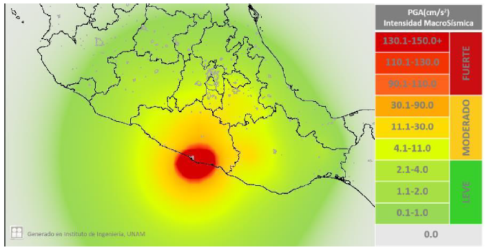
Fig. 4. Intensity Map of the tremor on September 07, 2021. Elaborated by the UNAM Engineering Institute.
According to the literature, this earthquake had a fault mechanism similar to the events of May 11 and 19, of 1962, with a magnitude 7.1 and 7.0 respectively; and the event of 1957, with a magnitude 7.7 (Ortiz et al., 2000). The rupture area, in the Acapulco region, is the same in the three earthquakes.
The Tsunami
Occurring an earthquake of magnitude 7.1 with an epicenter at the bottom of the sea, the earthquake of September 7 caused a tsunami that fortunately wasn’t destructive. This event was recorded with the stations of the National Network of Oceanographic and Meteorological Stations (RENEOM), see Fig. 5.
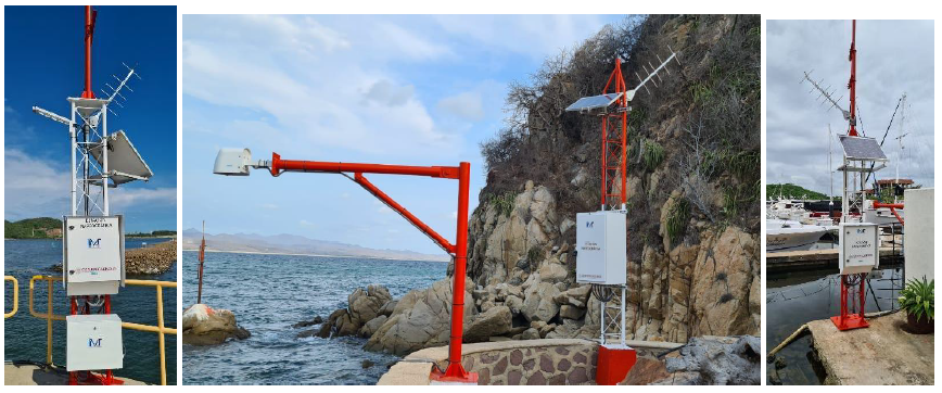
Fig. 5. RENEOM tide gauge stations
These Autonomous Electric Tide Gauge Stations measured variations in sea level and transmitted them continuously with the GOES satellite system. It is important to emphasize that without this satellite transmission system, the measurements would not have been able to transmit, as a consequence, to the interruption in all electrical supply in the region. The graphs in Fig. 6, show the sea level measurements made with the stations of the RENEOM and the information corroboration with the National Tide Gauge System (SMN).
Ixtapa, Guerrero.
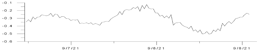
Zihuatanejo, Guerrero.
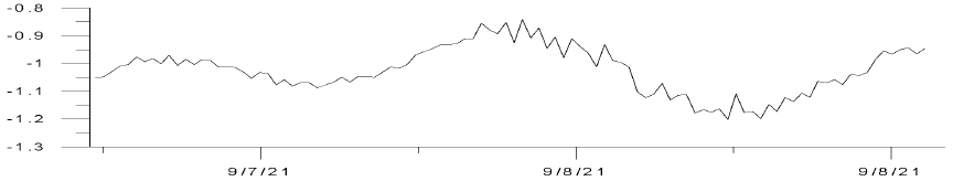
Acapulco, Guerrero.
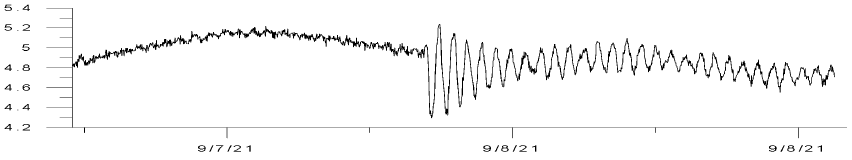
Fig. 6. Time graph of the sea level
From the measurements, it is observed that after the seismic
movement, the energy it was transmitted to the mass of water
located in front of the coast of Acapulco, and taking astronomical
tide levels as a reference, in the first instance, there was a drop in
the level of the sea (the sea receded); later, with the crest of the
first tsunami wave, the water level increased no more than 40
centimeters, which didn’t cause the sea overflow or any consequent
floods.
After the first wave, the oscillations of the tsunami dissipated until
the sea returned to its normal level in that area. In the stations near
the epicenter as Ixtapa and Zihuatanejo, in the state of Guerrero,
the effects of the tsunami were hardly perceived.
Case 2: January 15, 2022, eruption of the Tonga-Hunga Ha'apai volcano, near to the island of Fonuafo'ou, Tonga.
In accordance with the generated data measured with the tide stations of the National Network of Oceanographic and Meteorological Stations RENEOM, on Saturday, January 15 at approximately 11:00 Mexico-CST, extraordinarily sea level variations were recorded on the Mexican Pacific coast. Simultaneously, a tsunami arrived. This was the result of the eruption of the submarine volcano Hunga Tonga-Hunga Ha´apai, located approximately 30 kilometers southeast of the island of Fonuafoʻou, Tonga (Fig. 7).
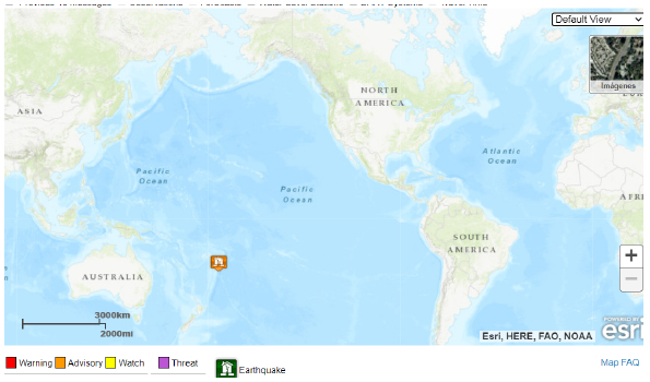
Fig. 7. Location of the Hunga Tonga-Hunga Ha´apai volcano.
The volcano erupted on Friday, January 14, 2022, at 22:26 Mexico-CST. Being on the bottom of the sea, the shock wave from the volcano eruption was transmitted to the water mass giving rise to the tsunami that spread through the waters of the Pacific Ocean (Fig. 8). 14
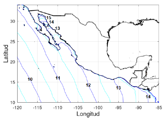
Fig. 8.-Stimated time graph of the Tsunami arrival
The Tsunami
Along the coast of Mexico, the tsunami waves didn’t generate floods, but did generate strong currents throughout the coastal strip (Fig. 9) that encompassed the port of Manzanillo in the state of Colima, where the effects of the tsunami were mostly perceived according to the records of RENEOM. The high oscillations of the sea level diminished rapidly; however, small disturbances persisted for some time in the coasts of Mexico.
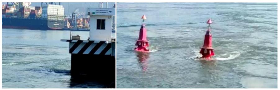
Fig. 9.- Marine currents in the access channel of the port of Manzanillo, Colima
It is important to point out that the measurements made with the RENEOM tide gauge stations were transmitted at 5-minute intervals through the GOES DCS satellite system (Fig. 10).
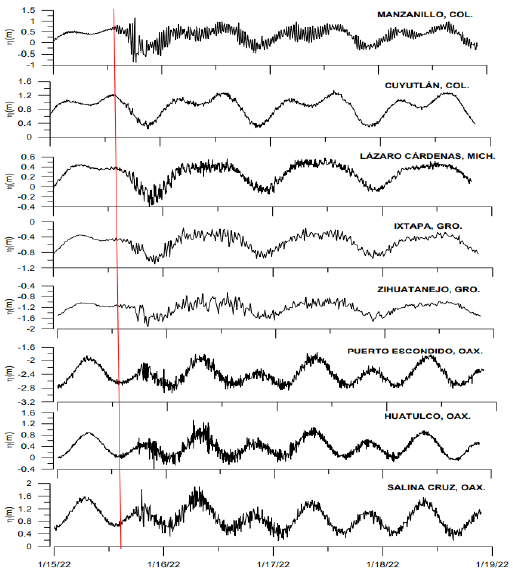
Fig. 10.- Gauge Stations measurements
Bibliography
RENEOM (2021) Red Nacional de Estaciones Oceanográficas y
Meteorológicas, Instituto Mexicano del Transporte, México.
Ortiz et al (2000): M. Ortíz, S. K. Singh, V. Kostologlodov y J. Pacheco,
Source areas of the Acapulco - San Marcos, Mexico earthquakes of 1962
(M 7.1; 7.0) and 1957 (M 7.7), as constrained by tsunami and uplift records.
Geofísica Internacional.
SSN (2021): Servicio Sismológico Nacional, Instituto de Geofísica,
Universidad Nacional Autónoma de México, México.